
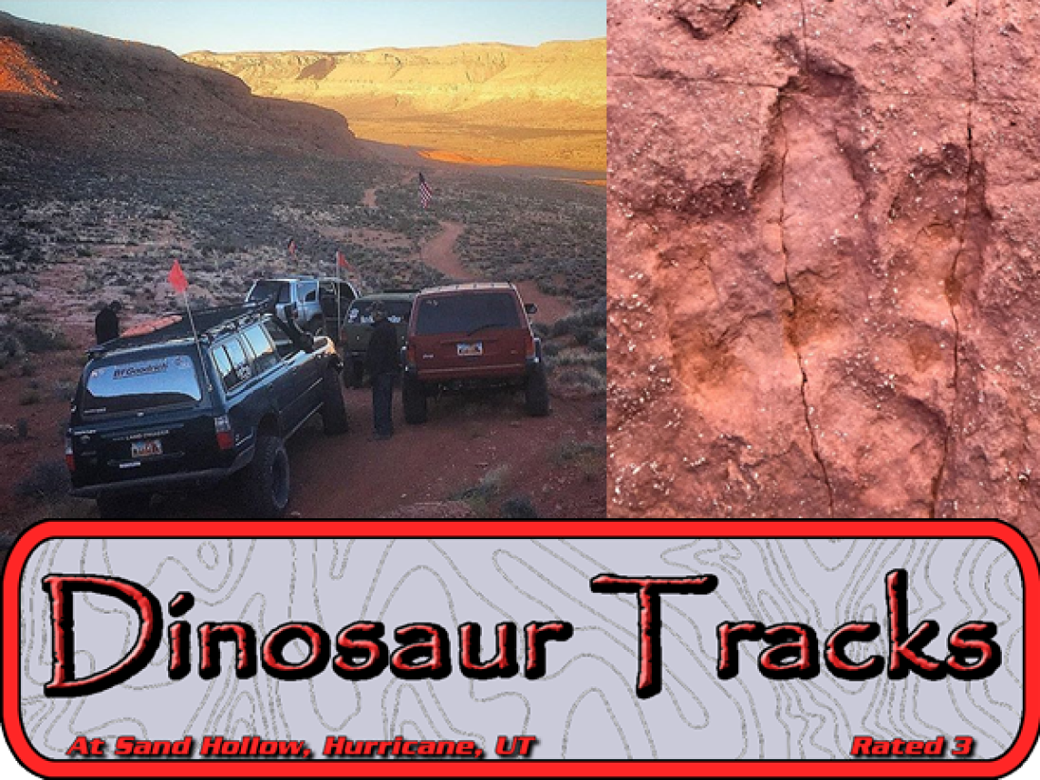
The Warner Valley Dinosaur Tracks are some of the most impressive in the area! There are at least three different types of dinosaur tracks evident in the rock strata. According to the archeologists who have studied the area, there are over 400 fossilized tracks! Not only is this a fun and easy trip with a easy and short hike with great historical value, but the area is shockingly beautiful! On your drive you will pass flaming red mountains and colorful clay filled rolling hills. The tracks are just a short walk from the parking lot! The trail heads up a small rise and then drops into a dry wash. The dry wash leads down to the dino tracks! Go walk with the Dinosaurs!
Surface
Two-track road with some ledges, up to 12". Sand dunes crossing with some uphill sand requiring momentum and wheel speed.
Trail Details
Dinosaur Tracks (Trail Hero Style) is a about 15 mile outs and back trail located near Hurricane, Utah that offers scenic views and is a great drive for stock four-wheel drive rigs. The trail is primarily used for camping and is accessible year-round.

East Rim Trail is a scenic route that travels from the base of the Hurricane Cliffs in Warner Valley, crossing over Sand Mountain via the East Rim to the West Rim and ending at the Washington Dam Road staging area. The 3 rating comes from several ledgy areas and a sand dunes crossing. Stock high clearance 4x4 vehicles with properly inflated (aired down) tires can successfully negotiate this trail.
Surface
Two-track road with some ledges, up to 12". Sand dunes crossing with some uphill sand requiring momentum and wheel speed.
Trail Details
East Rim Trail is a 23.2 mile out and back trail located near Hurricane, Utah that offers scenic views and is a great drive for stock four-wheel drive rigs. The trail is primarily used for camping and is accessible year-round.

The Honeymoon Trail derived its name from the time during the late 19th and early 20th centuries, when many engaged Mormon couples from southeastern Utah traveled the wagon road that took them to the St. George temple to be married, thereby enjoying their honeymoons on the trail during the return trip to their homes. This historic trail still has several original rock walls built to fortify the road as it ascends the canyon walls from Warner Valley to the top of the Hurricane Cliffs. This trail is easily travelled by stock high clearance 4x4 vehicles. When finished with the Honeymoon Trail, riders will venture over to Gooseberry Mesa for different perspective of both the Hurricane Valley and Zion National Park.
Surface
Two-track wagon road with several eroded ledgy areas that are a bit off camber.
Trail Details
The Honeymoon Trail follows Fort Pearce Wash and heads north through the Warner Valley into St. George. This scenic drive will take you along the old wagon road and through Warner Valley underneath the towering sandstone cliffs. There is a steep climb up to to the foot of the cliffs, then a rocky road that winds its way up two canyons in the Hurricane Cliffs. Just before the top of the climb, there is an off-camber section with a couple of small ledges to climb before reaching the top. The route from the top is mostly two-wheel drive, unless there has been recent inclement weather, which may create muddy conditions.
Moderate Trails Rated 4-6

Most of Milt’s Mile Light Trail follows along the edge of Milt’s Mile Trail. Several sections are part of the original Milt’s Mile, and a couple of sections are shared with the current Milt’s Mile. This trail affords spectacular views of Pine Valley Mountain, Sand Hollow Reservoir, Hurricane Cliffs, and Zion Park. During the Jamboree, there is a great spot to watch the “entertainment” when the 6-rated Milt’s Mile vehicles negotiate a tough section in the canyon below. A couple of intimidating sections at the beginning, earn a 4 rating. With good spotting on a few obstacles, stock high clearance 4x4 vehicles with competent drivers can successfully negotiate this trail. Much of the trail is easy slickrock and some sand.
Surface
Slickrock (sandstone) with several sections of two-track and some sand dunes at the end.
Trail Details
Milt’s Mile Light Trail begins at the Hurricane Water Tanks staging area. The access route follows along the north boundary fence on a two-track sand trail for 3/4 mile, turning south into a sandy wash, and up to a slickrock bowl where the fun begins. A couple of slickrock climbs provide a good warm up and an opportunity to see what stock-clearance vehicles are capable of doing. The bowl looks pretty tough, but careful driving and good spotting will award drivers with the feeling of conquering it. From here, the trail will go up a ledgy road, giving drivers a chance to check their clearance in a couple of spots. An overlook stop near the top of this section, is where you can watch the show as the 6-rated Milt’s Mile vehicles negotiate tough obstacles in the canyon below. The next section drops down a couple of ledges into a small canyon, and then up a bypass around “The Crack” obstacle on Milt’s Mile. The route continues up a wide section of slickrock, then crosses over a dry wash. A short trip along the base of some nice rock formations, including a large hoodoo, and you are out of the canyon. Be sure to stop at this point and enjoy the views looking back. From here, cross over a broken fence line, and head west 3/4 mile, then north to a cattle-guard crossing. Follow the sandy road north 1 1/4 miles to arrive at the Hurricane Water Tanks staging area.

This fun trail is a razzle of moderately challenging obstacles, followed by fabulous scenic dazzle! The run also includes a segment of Fathers Dominguez and Escalante historic trail.
Scenery
Razzle Dazzle offers 360* views of Sand Hollow Reservoir, Hurricane Cliffs, Warner Valley, Pine Valley Mountain, Kolob Cliffs, and Zion Canyon Mountains. On a clear day, you can see forever!
Surface
A mixture of sand and rocks will offer something for everyone!
Trail Details
Razzle Dazzle is a 4 rated trail, suitable for rigs with a lift and 33" tires. Lockers are not required. There will be obstacles in tight washes, and some deep sand travel, in addition to rocky climbs.

Most of West Rim Light Trail tours the rim of Sand Mountain, with spectacular views of Pine Valley Mountain, Sand Hollow Reservoir, St. George City, Warner Valley and the Hurricane Cliffs. The trail is mainly sandy road, with a few slickrock challenges and a sand dunes crossing. Stock 4x4 vehicles with properly inflated tires will enjoy this trail with a few challenges to prove their capabilities. Most of the trail is scenic four-wheeling.
Surface
Most of West Rim Lite trail is on sandy two-track road. The initial climb from the Washington Dam staging area is sand and clay. There are sandstone (slickrock) ledges along the way, and a loose stone climb from the rim up to West Rim Boulevard. There is a downhill sand dune crossing.
Trail Details
The Steps, a ledgy section has variable difficulty depending on the route chosen. Left is easy, and to the right is progressively more difficult. The Funnel is a rounded 30" ledge that requires a few rocks stacked for stock height vehicles. A loose stone climb from West Rim up to West Rim Boulevard requires 4 wheel drive. The sand dunes crossing at the midpoint is downhill. The East Rim section after the dunes has several ledgy areas with up to 12" ledges.